Santo Antônio do Aracanguá | |
|---|---|
Municipality | |
 | |
 Flag  Coat of arms | |
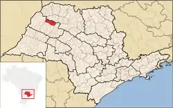 Location in São Paulo state | |
 Santo Antônio do Aracanguá Location in Brazil | |
| Coordinates: 20°56′20″S 50°29′44″W / 20.93889°S 50.49556°W | |
| Country | |
| Region | Southeast Brazil |
| State | São Paulo |
| Area | |
| • Total | 1,308.19 km2 (505.09 sq mi) |
| Population (2020 [1]) | |
| • Total | 8,481 |
| • Density | 6.5/km2 (17/sq mi) |
| Time zone | UTC−3 (BRT) |
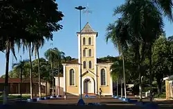
Santo Antônio do Aracanguá is a municipality in the northwestern part of the state of São Paulo, Brazil. The population is 8,481 (2020 est.) in an area of 1308.19 km².[2] The elevation is 385 m. The municipality was founded in 1993.
References
External links
- (in Portuguese) http://www.citybrazil.com.br/sp/stoantonioaracangua/
This article is issued from Wikipedia. The text is licensed under Creative Commons - Attribution - Sharealike. Additional terms may apply for the media files.