| Sarre | |
|---|---|
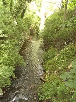 The Sarre by Wanzleben Castle | |
| Location | |
| Country | Germany |
| State | Saxony-Anhalt |
| District | Börde |
| Reference no. | DE: SAL19OW06-00 |
| Physical characteristics | |
| Source | |
| • location | Der große Teich |
| • coordinates | 52°06′21″N 11°21′47″E / 52.10582°N 11.363168°E |
| • elevation | 123.6 m above sea level (NN) |
| Mouth | |
• location | Groß Germersleben |
• coordinates | 51°59′47″N 11°22′12″E / 51.996495°N 11.370099°E |
• elevation | 72.1 m above sea level (NN) |
| Basin size | 67.50 km² [1] |
| Basin features | |
| Progression | Bode→ Saale→ Elbe→ North Sea |
| Landmarks | Small towns: Wanzleben-Börde |
| Tributaries | |
| • right | Röthebach, Sauerbach |
| Navigable | no |
The Sarre is a river in Saxony-Anhalt, Germany. It is a left tributary of the Bode, which it joins near Groß Germersleben.
See also
References
- ↑ Land Sachsen-Anhalt, ed. (2010), Messnetz des Landesbetriebes für Hochwasserschutz und Wasserwirtschaft Sachsen-Anhalt : Teil Oberirdische Gewässer (PDF) (in German), archived from the original (PDF) on 6 October 2014, retrieved 7 June 2010
This article is issued from Wikipedia. The text is licensed under Creative Commons - Attribution - Sharealike. Additional terms may apply for the media files.