Sawata
佐和田町 | |
|---|---|
Former municipality | |
 Flag  Seal | |
| Country | Japan |
| Region | Hokuriku |
| Prefecture | Niigata Prefecture |
| District | Sado District |
| Merged | March 1, 2004 (now part of Sado) |
| Area | |
| • Total | 47.7 km2 (18.4 sq mi) |
| Population (2004) | |
| • Total | 9,909 |
| Time zone | UTC+09:00 (JST) |
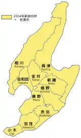
10 subdivisions (former municipalities) in the Sado City. Sawata is located on the west of the island.
Sawata (佐和田町, Sawata-machi) was a town located in Sado Island, Niigata Prefecture, Japan.[1]
On March 1, 2004, Sawata and the other 9 municipalities in the island were merged to create the city of Sado. Since then, Sawata has been one of the 10 subdivisions of Sado City.
Transportation
Bus
- Niigata Kotsu Sado
- Sawata Bus Station
Highway
See also
References
- ↑ "佐和田町" (PDF). Niigata Prefectural Government (in Japanese). Archived from the original (PDF) on 5 April 2004.
External links
- Sado Tourism Association (in English)
Dissolved municipalities of | |||||||
|---|---|---|---|---|---|---|---|
| Niigata |
| ||||||
| Murakami |
| ||||||
| Tainai |
| ||||||
| Shibata |
| ||||||
| Agano |
| ||||||
| Gosen |
| ||||||
| Aga |
| ||||||
| Tsubame |
| ||||||
| Sanjō |
| ||||||
| Nagaoka |
| ||||||
| Kashiwazaki |
| ||||||
| Tōkamachi |
| ||||||
| Uonuma |
| ||||||
| Minamiuonuma |
| ||||||
| Jōetsu |
| ||||||
| Myōkō (Arai) |
| ||||||
| Itoigawa |
| ||||||
| Sado |
| ||||||
This article is issued from Wikipedia. The text is licensed under Creative Commons - Attribution - Sharealike. Additional terms may apply for the media files.