Selas | |
|---|---|
.svg.png.webp) Seal | |
 | |
 Selas  Selas  Selas | |
| Coordinates: 40°57′9″N 2°6′2″W / 40.95250°N 2.10056°W | |
| Country | |
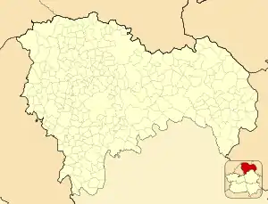
| Autonomous community | Castile-La Mancha |
| Province | Guadalajara |
| Comarca | Señorío de Molina-Alto Tajo |
| Area | |
| • Total | 44 km2 (17 sq mi) |
| Population (2018)[1] | |
| • Total | 47 |
| • Density | 1.1/km2 (2.8/sq mi) |
| Time zone | UTC+1 (CET) |
| • Summer (DST) | UTC+2 (CEST) |
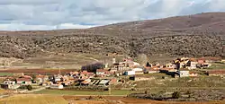
Selas is a municipality located in the province of Guadalajara, Castile-La Mancha, Spain. According to the 2004 census (INE), the municipality has a population of 63 inhabitants.
The Mesa River rises in the Sierra de Solorio range area near Selas.[2]
See also
References
- ↑ Municipal Register of Spain 2018. National Statistics Institute.
- ↑ El cañón del río Mesa, los castillos y el Camino del Cid
External links
This article is issued from Wikipedia. The text is licensed under Creative Commons - Attribution - Sharealike. Additional terms may apply for the media files.