| Semme | |
|---|---|
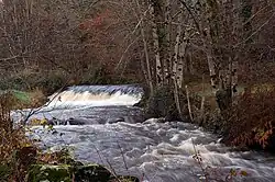 The Seem near Droux | |
  | |
| Location | |
| Country | France |
| Physical characteristics | |
| Source | |
| • location | Saint-Priest-la-Feuille |
| • coordinates | 46°11′47″N 01°32′20″E / 46.19639°N 1.53889°E |
| • elevation | 405 m (1,329 ft) |
| Mouth | |
• location | Gartempe |
• coordinates | 46°08′42″N 01°07′12″E / 46.14500°N 1.12000°E |
• elevation | 183 m (600 ft) |
| Length | 50.3 km (31.3 mi) |
| Basin size | 177 km2 (68 sq mi) |
| Discharge | |
| • average | 2 m3/s (71 cu ft/s) |
| Basin features | |
| Progression | Gartempe→ Creuse→ Vienne→ Loire→ Atlantic Ocean |
The Semme (French pronunciation: [sɛm]) is a 50.3-kilometre (31.3 mi) river in the Creuse and Haute-Vienne departments, in central France.[1] Its source is in Saint-Priest-la-Feuille. It flows generally west and is a right tributary of the Gartempe, into which it flows near le Bouchard, a hamlet in the municipality of Droux.
Departments and communes along its course
This list is ordered from source to mouth:
References
This article is issued from Wikipedia. The text is licensed under Creative Commons - Attribution - Sharealike. Additional terms may apply for the media files.