Shady Grove, Houston County, Texas | |
|---|---|
 Shady Grove  Shady Grove | |
| Coordinates: 31°14′03″N 95°19′26″W / 31.23417°N 95.32389°W | |
| Country | United States |
| State | Texas |
| County | Houston |
| Elevation | 308 ft (94 m) |
| Time zone | UTC-6 (Central (CST)) |
| • Summer (DST) | UTC-5 (CDT) |
| Area code | 936 |
| GNIS feature ID | 1382742[1] |
Shady Grove is a ghost town in Houston County, Texas, United States.[1]
History
Shady Grove was settled in the 1850s. It soon got a post office but closed in 1866. A Baptist church was built in the mid-1860s and was rebuilt in 1896. In the mid-1930s, the church, a cemetery, and a few houses were in the area. These details remained the same in the mid-1960s, even though World War II caused most of the residents to move away. By the 1990s it was all but abandoned.[2]
Geography
Shady Grove is located on U.S. Highway 287, approximately 10 miles southeast of Crockett in southeastern Houston County.[2]
Education
Most students in Shady Grove attend the Crockett Independent School District. The west side of County Road 4150 is in the Lovelady Independent School District.[3]
References
- 1 2 U.S. Geological Survey Geographic Names Information System: Shady Grove, Houston County, Texas
- 1 2 H., BISHOP, ELIZA (June 15, 2010). "SHADY GROVE, TX [HOUSTON COUNTY]". tshaonline.org. Retrieved April 21, 2018.
{{cite web}}: CS1 maint: multiple names: authors list (link) - ↑ "Crockett ISD :: School District Map of the Crockett ISD". MapTechnica. Retrieved April 21, 2018.
- "Lovelady ISD :: School District Map of the Lovelady ISD ::". MapTechnica. Retrieved April 21, 2018.
Municipalities and communities of Houston County, Texas, United States | ||
|---|---|---|
| Cities | 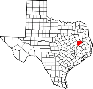 Houston County map | |
| Unincorporated communities |
| |
| Ghost towns |
| |
| Footnotes | ‡This populated place also has portions in an adjacent county or counties | |
This article is issued from Wikipedia. The text is licensed under Creative Commons - Attribution - Sharealike. Additional terms may apply for the media files.