| Shebandowan River | |
|---|---|
 | |
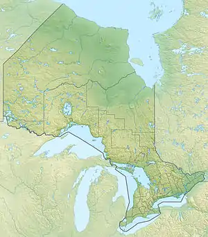 Location of the mouth of the Shebandowan River in Ontario | |
| Location | |
| Country | Canada |
| Province | Ontario |
| Region | Northeastern Ontario |
| District | Thunder Bay |
| Physical characteristics | |
| Source | Lower Shebandowan Lake |
| • location | Conacher Township |
| • coordinates | 48°37′11″N 90°03′45″W / 48.61972°N 90.06250°W |
| • elevation | 449 m (1,473 ft) |
| Mouth | Matawin River |
• location | Horne Township |
• coordinates | 48°32′56″N 89°53′27″W / 48.54889°N 89.89083°W |
• elevation | 366 m (1,201 ft) |
| Basin features | |
| River system | Great Lakes Basin |
| Tributaries | |
| • left | Oskondaga River |
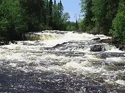
The Shebandowan River is a river in Thunder Bay District in Northwestern Ontario, Canada.[1] It is in the Great Lakes Basin and is a left tributary of the Matawin River. Three-quarters of the length of the river valley is paralleled by Ontario Highway 11, at this point part of the Trans-Canada Highway; and the entire length of the river valley is paralleled by a Canadian National Railway main line, built originally as the Canadian Northern Railway transcontinental main line.
Course
The river begins at Lower Shebandowan Lake,[2] part of a trio of lakes (Upper, Middle and Lower Shebandown lakes) known collectively as Shebandowan Lakes,[3] in geographic Conacher Township.[4] It exits the lake east over a dam at the community of Shebandowan,[5] passes into geographic Blackwell Township,[6] continues east into geographic Dawson Road Lots Township,[7] and takes in the left tributary Oskondaga River south of the community of Shabaqua Corners.[8] The river leaves Ontario Highway 11 and turns southeast into geographic Laurie Township,[9] passes the community of Shabaqua,[10] enters geographic Horne Township,[11] and reaches its mouth at the Matawin River. The Matawin River flows via the Kaministiquia River to Lake Superior.
Tributaries
- Oskondaga River (left)
See also
References
- ↑ "Shebandowan River". Geographical Names Data Base. Natural Resources Canada. Retrieved 2014-09-01.
- ↑ "Lower Shebandowan Lake". Geographical Names Data Base. Natural Resources Canada. Retrieved 2014-09-01.
- ↑ "Shebandowan Lakes". Geographical Names Data Base. Natural Resources Canada. Retrieved 2014-09-01.
- ↑ "Conacher" (PDF). Geology Ontario - Historic Claim Maps. Ontario Ministry of Northern Development, Mines and Forestry. Retrieved 2014-09-01.
- ↑ "Shebandowan". Geographical Names Data Base. Natural Resources Canada. Retrieved 2014-09-01.
- ↑ "Blackwell" (PDF). Geology Ontario - Historic Claim Maps. Ontario Ministry of Northern Development, Mines and Forestry. Retrieved 2014-09-01.
- ↑ "Dawson Road" (PDF). Geology Ontario - Historic Claim Maps. Ontario Ministry of Northern Development, Mines and Forestry. Archived from the original (PDF) on 2014-09-03. Retrieved 2014-09-01.
- ↑ "Shabaqua Corners". Geographical Names Data Base. Natural Resources Canada. Retrieved 2014-09-01.
- ↑ "Laurie" (PDF). Geology Ontario - Historic Claim Maps. Ontario Ministry of Northern Development, Mines and Forestry. Retrieved 2014-09-01.
- ↑ "Shabaqua". Geographical Names Data Base. Natural Resources Canada. Retrieved 2014-09-01.
- ↑ "Horne" (PDF). Geology Ontario - Historic Claim Maps. Ontario Ministry of Northern Development, Mines and Forestry. Archived from the original (PDF) on 2014-09-03. Retrieved 2014-09-01.
Sources
- Map 13 (PDF) (Map). 1 : 1,600,000. Official road map of Ontario. Ministry of Transportation of Ontario. 2014. Retrieved 2014-09-01.
- Restructured municipalities - Ontario map #2 (Map). Restructuring Maps of Ontario. Ontario Ministry of Municipal Affairs and Housing. 2006. Retrieved 2014-09-01.