Shemonaikha | |
|---|---|
District | |
| Шемонаиха ауданы | |
 Seal | |
 | |
| Country | |
| Region | East Kazakhstan Region |
| Administrative center | Shemonaikha |
| Founded | 1928 |
| Government | |
| • Akim | Akulov Grigory Iosifovich[1] |
| Area | |
| • Total | 4,000 km2 (2,000 sq mi) |
| Population (2013)[2] | |
| • Total | 46,409 |
| Time zone | UTC+6 (East) |
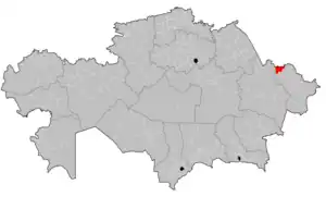
Shemonaikha (Kazakh: Шемонаиха ауданы, Şemonaiha audany) is a district of East Kazakhstan Region in eastern Kazakhstan. The administrative center of the district is the town of Shemonaikha.[3] Population: 46,409 (2013 estimate);[2] 49,202 (2009 Census results);[4] 57,815 (1999 Census results).[4]
Geography
Located in the north of East Kazakhstan Region. It borders in the east with Glubokovsky, in the west - with Borodulikha, in the south - with Ulansky districts of East Kazakhstan region, in the north - with Altai Territory Russian Federation.[5]
History
Shemonaikha district was formed on January 17, 1928 from Shemonaevskaya, parts of Kalininskaya, Ubinskaya volosts Semipalatinsk district and part of Krasnooktyabrskaya volost Ust-Kamenogorsk district with the center in the village of Shemonaikha. On June 11, 1959, the Arable Council, Verkhubinsky, Vydrikinsky and Bolsherechensky village councils of the abolished Verkh-Ubinsky district were attached to the Shemonaikha district.[6]
References
- ↑ "Акимат Шемонаихинского района". www.gov.kz.
- 1 2 "Население Республики Казахстан" (in Russian). Департамент социальной и демографической статистики. Retrieved 27 December 2013.
- ↑ www.geonames.de Subdivisions of Kazakhstan in local languages
- 1 2 "Население Республики Казахстан" [Population of the Republic of Kazakhstan] (in Russian). Департамент социальной и демографической статистики. Retrieved 8 December 2013.
- ↑ "Шемонаихинский район". e-arhiv.vko.gov.kz.
- ↑ Ведомости Верховного Совета СССР. № 24 (956), 1959 г.
Capital: Oskemen | ||
| Districts | 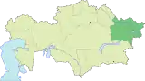 | |
| Cities of regional subordination | ||
| Major cities | ||
| Nuclear test sites | ||
50°37′46″N 81°54′17″E / 50.62944°N 81.90472°E