Six Points | |
|---|---|
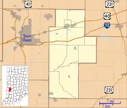 Six Points Location in Clay County | |
| Coordinates: 39°22′18″N 86°59′11″W / 39.37167°N 86.98639°W | |
| Country | United States |
| State | Indiana |
| County | Clay |
| Township | Washington |
| Elevation | 712 ft (217 m) |
| GNIS feature ID | 443557[1] |
Six Points is an unincorporated community in Washington Township, Clay County, Indiana. It is part of the Terre Haute Metropolitan Statistical Area.
History
Six Points was named for a 6-way intersection.[2]
Geography
Six Points is located at 39°22′18″N 86°59′11″W / 39.37167°N 86.98639°W.
References
- ↑ "Six Points, Indiana". Geographic Names Information System. United States Geological Survey, United States Department of the Interior. Retrieved August 20, 2010.
- ↑ Baker, Ronald L. (October 1995). From Needmore to Prosperity: Hoosier Place Names in Folklore and History. Indiana University Press. p. 302. ISBN 978-0-253-32866-3.
...named because four county roads converged here with State Road 46.
Municipalities and communities of Clay County, Indiana, United States | ||
|---|---|---|
| City | Map of Indiana highlighting Clay County | |
| Towns | ||
| Townships | ||
| CDPs | ||
| Other communities |
| |
| Ghost towns | ||
| Footnotes | ‡This populated place also has portions in an adjacent county or counties | |
This article is issued from Wikipedia. The text is licensed under Creative Commons - Attribution - Sharealike. Additional terms may apply for the media files.