Slavina | |
|---|---|
.jpg.webp) | |
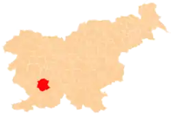
 Slavina Location in Slovenia | |
| Coordinates: 45°42′43.18″N 14°10′39.23″E / 45.7119944°N 14.1775639°E | |
| Country | |
| Traditional region | Inner Carniola |
| Statistical region | Littoral–Inner Carniola |
| Municipality | Postojna |
| Area | |
| • Total | 6.89 km2 (2.66 sq mi) |
| Elevation | 542 m (1,778 ft) |
| Population (2002) | |
| • Total | 206 |
| [1] | |
Slavina (pronounced [ˈslaːʋina]; German: Slawina,[2] Italian: Villa Slavina) is a village south of Postojna on the way to Pivka in the Inner Carniola region of Slovenia.[3]
The parish church in the settlement is dedicated to the Assumption of Mary and belongs to the Koper Diocese.[4]
References
- ↑ Statistical Office of the Republic of Slovenia
- ↑ Leksikon občin kraljestev in dežel zastopanih v državnem zboru, vol. 6: Kranjsko. Vienna: C. Kr. Dvorna in Državna Tiskarna. 1906. p. 136.
- ↑ Postojna municipal site
- ↑ Koper Diocese list of churches Archived 2009-03-06 at the Wayback Machine
External links
 Media related to Slavina at Wikimedia Commons
- Slavina on Geopedia
| Settlements | Administrative seat: Postojna
|  |
|---|---|---|
| Landmarks |
| |
| Notable people |
| |
This article is issued from Wikipedia. The text is licensed under Creative Commons - Attribution - Sharealike. Additional terms may apply for the media files.