| Snake River | |
|---|---|
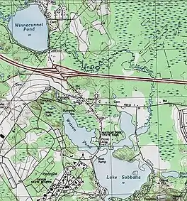 USGS map of the Snake River and surrounding areas | |
| Location | |
| Country | United States |
| State | Massachusetts |
| Physical characteristics | |
| Source | Winnecunnet Pond |
| • coordinates | 41°58′02″N 71°07′35″W / 41.9671°N 71.1265°W |
| Mouth | Lake Sabbatia |
• location | Taunton |
• coordinates | 41°56′51″N 71°06′38″W / 41.9475°N 71.1106°W |
| Length | 4 mi (6.4 km) |
The Snake River is a small river in Bristol County, Massachusetts. It flows 4.0 miles (6.4 km)[1] from Winnecunnet Pond to Lake Sabbatia in the northern part of Taunton, Massachusetts.
It is part of the Mill River-Taunton River-Narragansett Bay watersheds. The Snake River is part of the Canoe River Aquifer Area of Critical Environmental Concern (Massachusetts) (ACEC).[2][3]
References
- ↑ U.S. Geological Survey. National Hydrography Dataset high-resolution flowline data. The National Map, accessed April 1, 2011
- ↑ Massachusetts ACEC Map
- ↑ Massachusetts Canoe River Facts
This article is issued from Wikipedia. The text is licensed under Creative Commons - Attribution - Sharealike. Additional terms may apply for the media files.