Sollenau | |
|---|---|
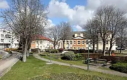 Main square with park and town hall | |
 Coat of arms | |
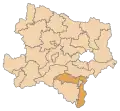
 Sollenau Location within Austria | |
| Coordinates: 47°54′N 16°15′E / 47.900°N 16.250°E | |
| Country | Austria |
| State | Lower Austria |
| District | Wiener Neustadt-Land |
| Government | |
| • Mayor | Stefan Wöckl (SPÖ) |
| Area | |
| • Total | 10.67 km2 (4.12 sq mi) |
| Elevation | 277 m (909 ft) |
| Population (2018-01-01)[2] | |
| • Total | 5,038 |
| • Density | 470/km2 (1,200/sq mi) |
| Time zone | UTC+1 (CET) |
| • Summer (DST) | UTC+2 (CEST) |
| Postal code | 2601 |
| Area code | 02628 |
| Vehicle registration | WB |
| Website | www.sollenau.noe.gv.at |
Sollenau is a municipality in the Wiener Neustadt-Land District, Lower Austria, Austria. Sollenau is situated on the river Piesting. 4.03% of the municipality is forested. It is 10 km north of Wiener Neustadt and 36 km south of Vienna.
Population
| Year | Pop. | ±% |
|---|---|---|
| 1971 | 2,781 | — |
| 1981 | 3,438 | +23.6% |
| 1991 | 4,213 | +22.5% |
| 2001 | 4,562 | +8.3% |
History
Sollenau was first mentioned in 1166. It is one of the oldest settlements in the Steinfeld region of Lower Austria.
Economy
In 2001 there were 191 non-agriculture-related jobs in the municipality, and 2,055 persons were employed. The activity rate was 45,92%. In 1999 there were 27 agricultural or forestry related companies.
References
- ↑ "Dauersiedlungsraum der Gemeinden Politischen Bezirke und Bundesländer - Gebietsstand 1.1.2018". Statistics Austria. Retrieved 10 March 2019.
- ↑ "Einwohnerzahl 1.1.2018 nach Gemeinden mit Status, Gebietsstand 1.1.2018". Statistics Austria. Retrieved 9 March 2019.
External links
- Pfarre Sollenau - Laurentius (in German)
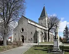
Parish church
This article is issued from Wikipedia. The text is licensed under Creative Commons - Attribution - Sharealike. Additional terms may apply for the media files.