South Carolina Highway 212 | ||||
|---|---|---|---|---|
 | ||||
| Route information | ||||
| Maintained by SCDOT | ||||
| Length | 5.670 mi[1] (9.125 km) | |||
| Existed | 1938–present | |||
| Major junctions | ||||
| South end |  SC 64 near Bells Crossroads SC 64 near Bells Crossroads | |||
| North end |  US 21 near Williams US 21 near Williams | |||
| Location | ||||
| Country | United States | |||
| State | South Carolina | |||
| Counties | Colleton | |||
| Highway system | ||||
| ||||


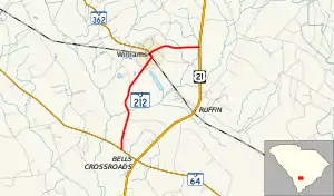
South Carolina Highway 212 (SC 212) is a 5.670-mile (9.125 km) primary state highway in the U.S. state of South Carolina. It serves the town of Williams by connecting it with nearby highways.
Route description
SC 212 is a two-lane rural highway that connects the town of Williams between SC 64 and U.S. Route 21 (US 21). Within Williams, it intersects SC 362 at its eastern terminus.[2]
History
Established around 1938 as a new primary routing as a spur from US 21 to Williams. In 1940, it was extended south to its current southern terminus at SC 64. In 1950, the entire route was completely paved.[3]
Major intersections
The entire route is in Colleton County.
| Location | mi[1] | km | Destinations | Notes | |
|---|---|---|---|---|---|
| | 0.000 | 0.000 | SC 64 (Lodge Highway) – Lodge, Walterboro | Southern terminus | |
| | 0.150 | 0.241 | Sykes Road east (SC 212 Conn. east) | Western terminus of SC 212 Conn. | |
| Williams | 3.810 | 6.132 |   SC 362 west (Lumber Road) SC 362 west (Lumber Road) | Eastern terminus of SC 362 | |
| | 5.670 | 9.125 | US 21 (Low Country Highway) – Yemassee, Branchville | Northern terminus | |
| 1.000 mi = 1.609 km; 1.000 km = 0.621 mi | |||||
Bells Crossroads connector route
South Carolina Highway 212 Connector | |
|---|---|
| Location | Bells Crossroads, South Carolina |
| Length | 0.130 mi[4] (209 m) |

South Carolina Highway 212 Connector (SC 212 Conn.) is a connector route that exists just northwest of Bells Crossroads. It connects SC 64 (Bells Highway) with the SC 212 mainline (Williams Road) just north of SC 212's southern terminus.[5]
See also

References
- 1 2 "Highway Logmile Report". South Carolina Department of Transportation. Retrieved December 2, 2020.
- ↑ Google (September 7, 2013). "South Carolina Highway 212" (Map). Google Maps. Google. Retrieved September 7, 2013.
- ↑ General Highway Map, Colleton County, South Carolina (PDF) (Map). Cartography by SCDOT. South Carolina Department of Transportation. 1943. Retrieved September 10, 2013.
- ↑ "Highway Logmile Report". South Carolina Department of Transportation. Retrieved December 2, 2020.
- ↑ Google (December 2, 2020). "Overview map of SCC 212 Conn. (Bells Crossroads)" (Map). Google Maps. Google. Retrieved December 2, 2020.
External links
 Media related to South Carolina Highway 212 at Wikimedia Commons
- Mapmikey's South Carolina Highways Page: SC 212