Southwest | |
|---|---|
 | |
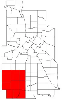 Location of Southwest within the U.S. city of Minneapolis | |
| Country | United States |
| State | Minnesota |
| County | Hennepin |
| City | Minneapolis |
| Founded | 1849 |
| Neighborhoods | |
| Area | |
| • Total | 8.142 sq mi (21.09 km2) |
| Population (2020)[2] | |
| • Total | 50,658 |
| • Density | 6,200/sq mi (2,400/km2) |
| Time zone | UTC-6 (CST) |
| • Summer (DST) | UTC-5 (CDT) |
| ZIP code | 55408, 55409, 55410, 55416, 55419 |
| Area code | 612 |
| Census | Pop. | Note | %± |
|---|---|---|---|
| 1980 | 52,946 | — | |
| 1990 | 49,590 | −6.3% | |
| 2000 | 47,863 | −3.5% | |
| 2010 | 48,076 | 0.4% | |
| 2020 | 50,658 | 5.4% |
The Southwest community consists of the following neighborhoods: Linden Hills, East Harriet, Kingfield, Fulton, Lynnhurst, Tangletown, Armatage, Kenny, and Windom. This portion of Minneapolis contains many parks and trails along Lake Harriet and Minnehaha Creek.
References
- ↑ "Southwest neighborhood in Minneapolis, Minnesota (MN), 55409, 55410, 55419 detailed profile". City-Data. 2011. Retrieved 2013-11-12.
- ↑ "Southwest community data". Minnesota Compass. Retrieved 2023-04-02.
External links
- Southwest Business Association (SWBA)
- Experience Southwest : Southwest Minneapolis Business Directory (NEHBA sponsored)
- Businesses in Southwest Minneapolis

Wikivoyage has a travel guide for Southwest Minneapolis.
This article is issued from Wikipedia. The text is licensed under Creative Commons - Attribution - Sharealike. Additional terms may apply for the media files.