Sainte-Croix | |
|---|---|
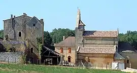 Church and priory | |
Location of Sainte-Croix | |
 Sainte-Croix  Sainte-Croix | |
| Coordinates: 44°44′26″N 0°49′54″E / 44.7406°N 0.8317°E | |
| Country | France |
| Region | Nouvelle-Aquitaine |
| Department | Dordogne |
| Arrondissement | Bergerac |
| Canton | Lalinde |
| Government | |
| • Mayor (2020–2026) | Francis Montaudouin[1] |
| Area 1 | 12.87 km2 (4.97 sq mi) |
| Population | 87 |
| • Density | 6.8/km2 (18/sq mi) |
| Time zone | UTC+01:00 (CET) |
| • Summer (DST) | UTC+02:00 (CEST) |
| INSEE/Postal code | 24393 /24440 |
| Elevation | 80–209 m (262–686 ft) (avg. 165 m or 541 ft) |
| 1 French Land Register data, which excludes lakes, ponds, glaciers > 1 km2 (0.386 sq mi or 247 acres) and river estuaries. | |
Sainte-Croix (French pronunciation: [sɛ̃t kʁwa] ⓘ; also Sainte-Croix-de-Beaumont; Languedocien: Senta Crotz) is a commune in the Dordogne department in Nouvelle-Aquitaine in southwestern France.
The village has an ancient church and attached building that used to belong to the Knights Templar. The mayor of Sainte-Croix is Francis Montaudouin, elected in 2020.[1] Sainte-Croix lies about 3 km to the east of the D660 road that links Beaumont-du-Périgord in the north and Monpazier in the south.
Population
| Year | Pop. | ±% |
|---|---|---|
| 1962 | 134 | — |
| 1968 | 113 | −15.7% |
| 1975 | 91 | −19.5% |
| 1982 | 84 | −7.7% |
| 1990 | 94 | +11.9% |
| 1999 | 95 | +1.1% |
| 2008 | 89 | −6.3% |
See also
References
- 1 2 "Répertoire national des élus: les maires" (in French). data.gouv.fr, Plateforme ouverte des données publiques françaises. 4 May 2022.
- ↑ "Populations légales 2021". The National Institute of Statistics and Economic Studies. 28 December 2023.
External links
Wikimedia Commons has media related to Sainte-Croix (Dordogne).
This article is issued from Wikipedia. The text is licensed under Creative Commons - Attribution - Sharealike. Additional terms may apply for the media files.