| Stob Binnein | |
|---|---|
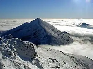 Stob Binnein from Ben More in a winter temperature inversion | |
| Highest point | |
| Elevation | 1,165 m (3,822 ft)[1] |
| Prominence | 303 m (994 ft) |
| Parent peak | Ben More |
| Listing | Munro, Marilyn |
| Naming | |
| English translation | Conical peak |
| Language of name | Gaelic |
| Pronunciation | Scottish Gaelic: [ˈs̪t̪op ˈpiɲɛɲ] ⓘ |
| Geography | |
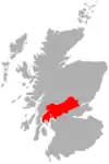
| Location | Stirling council area, Scotland |
| OS grid | NN435228 |
| Topo map | OS Landranger 51 and Explorer 365 |
Stob Binnein is a mountain in the southern Highlands of Scotland, near Crianlarich. It forms a twin-peak with Ben More 3,852 ft (1,174 m), from which it is separated by the Bealach-eadar-dha Beinn, meaning pass between two hills.
Stob Binnein is often climbed in conjunction with Ben More by means of the Bealach-eadar-dha Beinn. Descent may be made from the bealach direct to Benmore Burn. It may also be climbed from the south, starting near Inverlochlarig, some 8 km from Balquhidder. A route of about 5 km climbs from the glen, following the mountain's southern ridge over the intervening minor summits of Stob Invercarnaig and Stob Coire an Lochain.
See also
References
- ↑ "Stob Binnein". Hill Bagging - the online version of the Database of British and Irish Hills (DoBIH). 2019. Retrieved 20 June 2019.
56°22′18″N 4°32′08″W / 56.37153°N 4.53551°W
 | | ||
This article is issued from Wikipedia. The text is licensed under Creative Commons - Attribution - Sharealike. Additional terms may apply for the media files.