Straußfurt | |
|---|---|
 Coat of arms | |
Location of Straußfurt within Sömmerda district 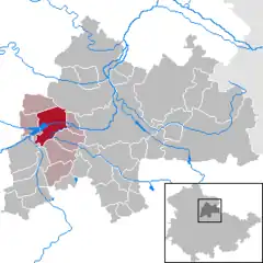 | |
 Straußfurt 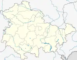 Straußfurt | |
| Coordinates: 51°10′N 10°59′E / 51.167°N 10.983°E | |
| Country | Germany |
| State | Thuringia |
| District | Sömmerda |
| Municipal assoc. | Straußfurt |
| Government | |
| • Mayor (2021–27) | Olaf Starroske[1] |
| Area | |
| • Total | 21.85 km2 (8.44 sq mi) |
| Elevation | 150 m (490 ft) |
| Population (2022-12-31)[2] | |
| • Total | 2,094 |
| • Density | 96/km2 (250/sq mi) |
| Time zone | UTC+01:00 (CET) |
| • Summer (DST) | UTC+02:00 (CEST) |
| Postal codes | 99634 |
| Dialling codes | 036376 |
| Vehicle registration | SÖM |
| Website | www.straussfurt.de |
Straußfurt is a municipality in the Sömmerda district of Thuringia, Germany. The former municipality Henschleben was merged into Straußfurt in December 2019.
References
- ↑ Gewählte Bürgermeister - aktuelle Landesübersicht, Freistaat Thüringen, accessed 14 July 2021.
- ↑ "Bevölkerung der Gemeinden, erfüllenden Gemeinden und Verwaltungsgemeinschaften in Thüringen Gebietsstand: 31.12.2022" (in German). Thüringer Landesamt für Statistik. June 2023.
This article is issued from Wikipedia. The text is licensed under Creative Commons - Attribution - Sharealike. Additional terms may apply for the media files.