Suben | |
|---|---|
 | |
 Coat of arms | |
 Suben Location within Austria | |
| Coordinates: 48°25′00″N 13°26′00″E / 48.41667°N 13.43333°E | |
| Country | Austria |
| State | Upper Austria |
| District | Schärding |
| Government | |
| • Mayor | Ernst Johann Seitz (ÖVP) |
| Area | |
| • Total | 6.4 km2 (2.5 sq mi) |
| Elevation | 329 m (1,079 ft) |
| Population (2018-01-01)[2] | |
| • Total | 1,508 |
| • Density | 240/km2 (610/sq mi) |
| Time zone | UTC+1 (CET) |
| • Summer (DST) | UTC+2 (CEST) |
| Postal code | 4975 |
| Area code | 07711 |
| Vehicle registration | SD |
| Website | www.suben.at |
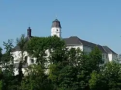
Suben is a municipality in the district of Schärding in the Austrian state of Upper Austria. It is not far from the Austrian-German border.
Geography
Suben lies in the Innviertel. About 13 percent of the municipality is forest, and 58 percent is farmland.
References
- ↑ "Dauersiedlungsraum der Gemeinden Politischen Bezirke und Bundesländer - Gebietsstand 1.1.2018". Statistics Austria. Retrieved 10 March 2019.
- ↑ "Einwohnerzahl 1.1.2018 nach Gemeinden mit Status, Gebietsstand 1.1.2018". Statistics Austria. Retrieved 9 March 2019.
Wikimedia Commons has media related to Suben.
This article is issued from Wikipedia. The text is licensed under Creative Commons - Attribution - Sharealike. Additional terms may apply for the media files.