Suchanino | |
|---|---|
District of Gdańsk | |
 Aerial view of Suchanino in January 2005 | |
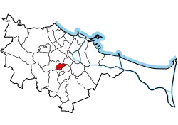 Location of Suchanino within Gdańsk | |
| Coordinates: 54°22′N 18°39′E / 54.367°N 18.650°E | |
| Country | |
| Voivodeship | Pomeranian |
| County/City | Gdańsk |
| Within city limits | 1902 |
| Area | |
| • Total | 1.44 km2 (0.56 sq mi) |
| Population (2019[1]) | |
| • Total | 10,323 |
| • Density | 7,200/km2 (19,000/sq mi) |
| Time zone | UTC+1 (CET) |
| • Summer (DST) | UTC+2 (CEST) |
| Vehicle registration | GD |
Suchanino (Kashubian: Cëgónczi, German: Zigankenberg) is a district of Gdańsk, Poland, located in the central part of the city. With 12,937 inhabitants in an area of 1.3 km2 it has a population density of 9,812 inhabitants/km2. Most buildings are high-rise and were constructed in the 1970s.
During World War II, the Germans established and operated a subcamp of the Stutthof concentration camp in the district.[2] The prisoners were subjected to forced labour at a local brickyard.[2]
References
External links
- Map of Suchanino
- Old map of Zigankenberg
- http://www.zeno.org/Meyers-1905/A/Zigankenberg
- http://www.xs4all.nl/~wolfzim/origine.html
This article is issued from Wikipedia. The text is licensed under Creative Commons - Attribution - Sharealike. Additional terms may apply for the media files.