Syřenov | |
|---|---|
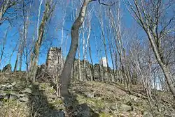 Ruin of Kumburk Castle | |
 Flag  Coat of arms | |
 Syřenov Location in the Czech Republic | |
| Coordinates: 50°29′56″N 15°25′40″E / 50.49889°N 15.42778°E | |
| Country | |
| Region | Liberec |
| District | Semily |
| First mentioned | 1533 |
| Area | |
| • Total | 6.46 km2 (2.49 sq mi) |
| Elevation | 448 m (1,470 ft) |
| Population (2023-01-01)[1] | |
| • Total | 225 |
| • Density | 35/km2 (90/sq mi) |
| Time zone | UTC+1 (CET) |
| • Summer (DST) | UTC+2 (CEST) |
| Postal code | 512 71 |
| Website | syrenov |
Syřenov is a municipality and village in Semily District in the Liberec Region of the Czech Republic. It has about 200 inhabitants.
Administrative parts
Villages of Újezdec and Žďár u Kumburku are administrative parts of Syřenov.
References
Wikimedia Commons has media related to Syřenov.
This article is issued from Wikipedia. The text is licensed under Creative Commons - Attribution - Sharealike. Additional terms may apply for the media files.