Sycamore, Kansas | |
|---|---|
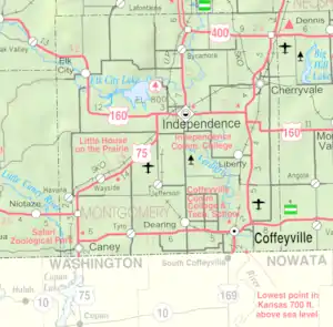 KDOT map of Montgomery County (legend) | |
 Sycamore  Sycamore | |
| Coordinates: 37°19′29″N 95°42′55″W / 37.32472°N 95.71528°W[1] | |
| Country | United States |
| State | Kansas |
| County | Montgomery |
| Elevation | 840 ft (260 m) |
| Population | |
| • Total | 70 |
| Time zone | UTC-6 (CST) |
| • Summer (DST) | UTC-5 (CDT) |
| ZIP code | 67363 |
| Area code | 620 |
| FIPS code | 20-69725 |
| GNIS ID | 2804501[1] |
Sycamore is an unincorporated community in northern Montgomery County, Kansas, United States.[1] As of the 2020 census, the population of the community and nearby areas was 70.[2] It is located along U.S. Route 75 north of the city of Independence.
History
Sycamore was founded when the railroad was first built through the area.[3]
The post office, established as Lay in 1887, was renamed Sycamore in 1896.[4] It has a post office with the ZIP code 67363.[5]
Climate
The climate in this area is characterized by hot, humid summers and generally mild to cool winters. According to the Köppen Climate Classification system, Sycamore has a humid subtropical climate, abbreviated "Cfa" on climate maps.[6]
Demographics
| Census | Pop. | Note | %± |
|---|---|---|---|
| 2020 | 70 | — | |
| U.S. Decennial Census | |||
For statistical purposes, the United States Census Bureau has defined this community as a census-designated place (CDP).
Education
The community is served by Independence USD 446 public school district.
References
- 1 2 3 4 U.S. Geological Survey Geographic Names Information System: Sycamore, Kansas
- 1 2 "Profile of Sycamore, Kansas (CDP) in 2020". United States Census Bureau. Archived from the original on May 31, 2022. Retrieved May 31, 2022.
- ↑ Duncan, L. Wallace (1903). History of Montgomery County, Kansas. Press of Iola Register. pp. 82.
- ↑ "Kansas Post Offices, 1828-1961". Kansas Historical Society. Retrieved June 16, 2014.
- ↑ USPS – Cities by ZIP Code
- ↑ Climate Summary for Sycamore, Kansas
Further reading
External links
Municipalities and communities of Montgomery County, Kansas, United States | ||
|---|---|---|
| Cities | 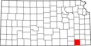 Map of Kansas highlighting Montgomery County | |
| Unincorporated communities | ||
| Ghost towns | ||
| Footnotes | †This community is designated a Census-Designated Place (CDP) by the United States Census Bureau. | |