Tautenhain | |
|---|---|
Location of Tautenhain within Saale-Holzland-Kreis district 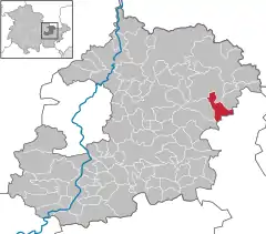 | |
 Tautenhain 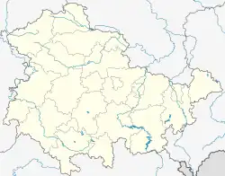 Tautenhain | |
| Coordinates: 50°55′26″N 11°55′5″E / 50.92389°N 11.91806°E | |
| Country | Germany |
| State | Thuringia |
| District | Saale-Holzland-Kreis |
| Municipal assoc. | Bad Klosterlausnitz |
| Government | |
| • Mayor (2022–28) | Daniel Steuer[1] |
| Area | |
| • Total | 8.91 km2 (3.44 sq mi) |
| Elevation | 330 m (1,080 ft) |
| Population (2022-12-31)[2] | |
| • Total | 904 |
| • Density | 100/km2 (260/sq mi) |
| Time zone | UTC+01:00 (CET) |
| • Summer (DST) | UTC+02:00 (CEST) |
| Postal codes | 07639 |
| Dialling codes | 036601 |
| Vehicle registration | SHK, EIS, SRO |
| Website | www.bad-klosterlausnitz.de |
Tautenhain is a municipality in the district Saale-Holzland, in Thuringia, Germany.
References
- ↑ Gewählte Bürgermeister - aktuelle Landesübersicht, Freistaat Thüringen, accessed 10 November 2022.
- ↑ "Bevölkerung der Gemeinden, erfüllenden Gemeinden und Verwaltungsgemeinschaften in Thüringen Gebietsstand: 31.12.2022" (in German). Thüringer Landesamt für Statistik. June 2023.
This article is issued from Wikipedia. The text is licensed under Creative Commons - Attribution - Sharealike. Additional terms may apply for the media files.