Taylor, Louisiana | |
|---|---|
 Taylor, Louisiana  Taylor, Louisiana | |
| Coordinates: 32°32′45″N 93°07′10″W / 32.54583°N 93.11944°W | |
| Country | United States |
| State | Louisiana |
| Parish | Bienville |
| Elevation | 223 ft (68 m) |
| Time zone | UTC-6 (Central (CST)) |
| • Summer (DST) | UTC-5 (CDT) |
| ZIP code | 71080 |
| Area code | 318 |
| GNIS feature ID | 543715[1] |
Taylor is an unincorporated community in Bienville Parish, Louisiana, United States.[1] Its ZIP code is 71080.[2]
Notes
- 1 2 "Taylor, Louisiana". Geographic Names Information System. United States Geological Survey, United States Department of the Interior.
- ↑ United States Postal Service (2012). "USPS - Look Up a ZIP Code". Retrieved February 15, 2012.
Municipalities and communities of Bienville Parish, Louisiana, United States | ||
|---|---|---|
| Towns | 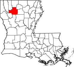 | |
| Villages | ||
| Unincorporated communities | ||
This article is issued from Wikipedia. The text is licensed under Creative Commons - Attribution - Sharealike. Additional terms may apply for the media files.