Thio | |
|---|---|
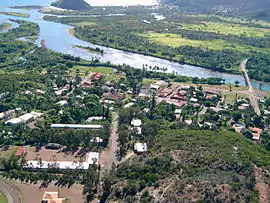 An aerial view of the village of Thio | |
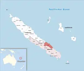 Location of the commune (in red) within New Caledonia | |
Location of Thio | |
| Coordinates: 21°37′S 166°13′E / 21.62°S 166.22°E | |
| Country | France |
| Sui generis collectivity | New Caledonia |
| Province | South Province |
| Government | |
| • Mayor (2020–2026) | Jean-Patrick Toura[1] |
| Area 1 | 997.6 km2 (385.2 sq mi) |
| Population (2019 census)[2] | 2,524 |
| • Density | 2.5/km2 (6.6/sq mi) |
| Ethnic distribution | |
| • 2019 census | Kanaks 76.58% Europeans 3.8% Wallisians and Futunans 3.45% Mixed 10.14% Other 6.02% |
| Time zone | UTC+11:00 |
| INSEE/Postal code | 98829 /98829 |
| Elevation | 0–1,618 m (0–5,308 ft) (avg. 10 m or 33 ft) |
| 1 New Caledonia Land Register (DITTT) data, which exclude lakes and ponds larger than 1 km² (0.386 sq mi or 247 acres) as well as the estuaries of rivers. | |
Thio is a commune in the South Province of New Caledonia, an overseas territory of France in the Pacific Ocean.
A novel Aerial tramway built by Adolf Bleichert & Co. company in 1906 existed here at the start of the 20th century to facilitate loading ore ships offshore.
References
- ↑ "Répertoire national des élus: les maires" (in French). data.gouv.fr, Plateforme ouverte des données publiques françaises. 13 September 2022.
- ↑ Population, ménages et logement par commune, en 2019, Institut de la statistique et des études économiques Nouvelle-Calédonie
- https://archive.org/details/selectedbibliogr00amerrich 1916. pg 15 “about one thousand yards long”. Refers to Scientific American Supplement November 27, 1909 and Engineering & Mining Journal February 20, 1909 5 pages, illustrated.
- http://www.zapgillou.fr/mondalazac/articleweb/partie2.htm has a postage stamp, a short description and a Google Earth view.
Wikimedia Commons has media related to Thio.
| Provinces | |
|---|---|
| Communes | |
This article is issued from Wikipedia. The text is licensed under Creative Commons - Attribution - Sharealike. Additional terms may apply for the media files.