| Torse | |
|---|---|
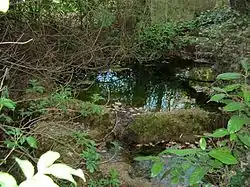 The Prignon in Saint-Marc-Jaumegarde | |
  | |
| Location | |
| Country | France |
| Physical characteristics | |
| Mouth | Arc |
• coordinates | 43°30′42″N 5°28′09″E / 43.5117°N 5.4693°E |
| Length | 8.0 km (5.0 mi) |
| Basin features | |
| Progression | Arc→ Étang de Berre→ Mediterranean Sea |
The Torse (in its upper course also Ruisseau du Prignon)[1] is a stream in the southeast of France. It runs from Saint-Marc-Jaumegarde to the Arc in Aix-en-Provence.[2] It is 8 kilometres (5 mi) long.[2]
References
This article is issued from Wikipedia. The text is licensed under Creative Commons - Attribution - Sharealike. Additional terms may apply for the media files.