Tourém | |
|---|---|
 | |
| Coordinates: 41°53′34″N 7°57′14″W / 41.8929°N 7.9539°W | |
| Country | |
| Region | Norte |
| Intermunic. comm. | Alto Tâmega |
| District | Vila Real |
| Municipality | Montalegre |
| Area | |
| • Total | 16.61 km2 (6.41 sq mi) |
| Population (2021) | |
| • Total | 112 |
| • Density | 6.7/km2 (17/sq mi) |
| Time zone | UTC±00:00 (WET) |
| • Summer (DST) | UTC+01:00 (WEST) |
| Postal code | 5470 |
| Patron | Sao Pedro |
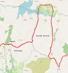
Tourém is a village and parish (freguesia) in the municipality of Montalegre in the far north of Portugal. The main part of the territory of the parish stretches as a small peninsula of Portuguese land within Spanish territory. The northern extremity of the parish is, in formal terms, a Portuguese exclave within Spain, being separated from the rest of the Parish, and the rest of Portugal, by a lake in Spanish territory. This is one of only two exclaves of Portugal. The parish has an area of 16,61 km² and 112 inhabitants (2021).[1]
References
This article is issued from Wikipedia. The text is licensed under Creative Commons - Attribution - Sharealike. Additional terms may apply for the media files.