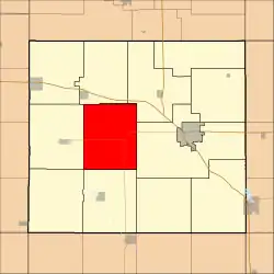
Ulster Township | |
|---|---|
 Location in Floyd County | |
| Coordinates: 43°03′50″N 92°50′54″W / 43.06389°N 92.84833°W | |
| Country | |
| State | |
| County | Floyd |
| Area | |
| • Total | 41.51 sq mi (107.51 km2) |
| • Land | 41.51 sq mi (107.51 km2) |
| • Water | 0 sq mi (0 km2) 0% |
| Elevation | 1,040 ft (317 m) |
| Population (2000) | |
| • Total | 373 |
| • Density | 9/sq mi (3.5/km2) |
| Time zone | UTC-6 (CST) |
| • Summer (DST) | UTC-5 (CDT) |
| ZIP codes | 50435, 50468, 50471, 50616 |
| GNIS feature ID | 0468804 |
Ulster Township is one of twelve townships in Floyd County, Iowa, USA. As of the 2000 census, its population was 373.[1]
Geography
According to the United States Census Bureau, Ulster Township covers an area of 41.51 square miles (107.51 square kilometers).
Unincorporated towns
- Carney at 43°01′45″N 92°48′38″W / 43.029138°N 92.810471°W
- Roseville at 43°00′33″N 92°48′36″W / 43.009138°N 92.809915°W
(This list is based on USGS data and may include former settlements.)
Adjacent townships
- Rudd Township (north)
- Floyd Township (northeast)
- Saint Charles Township (east)
- Union Township (south)
- Scott Township (southwest)
- Rockford Township (west)
Cemeteries
Ulster Township contains Ulsterville Cemetery
Major highways
School districts
- Charles City Community School District
- Rudd-Rockford-Marble Rock Community School District
Political districts
- Iowa's 4th congressional district
- State House District 14
- State Senate District 7
References
- United States Census Bureau 2008 TIGER/Line Shapefiles
- United States Board on Geographic Names (GNIS)
- United States National Atlas
- ↑ "U.S. Census website". Retrieved May 15, 2009.
External links
This article is issued from Wikipedia. The text is licensed under Creative Commons - Attribution - Sharealike. Additional terms may apply for the media files.