Unstruttal | |
|---|---|
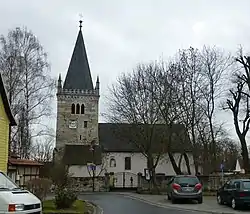 Saint Vitus Church in Ammern | |
 Coat of arms | |
Location of Unstruttal within Unstrut-Hainich-Kreis district 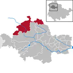 | |
 Unstruttal  Unstruttal | |
| Coordinates: 51°14′N 10°27′E / 51.233°N 10.450°E | |
| Country | Germany |
| State | Thuringia |
| District | Unstrut-Hainich-Kreis |
| Government | |
| • Mayor (2019–25) | Michael Hartung[1] (Ind.) |
| Area | |
| • Total | 100.48 km2 (38.80 sq mi) |
| Elevation | 229 m (751 ft) |
| Population (2022-12-31)[2] | |
| • Total | 6,130 |
| • Density | 61/km2 (160/sq mi) |
| Time zone | UTC+01:00 (CET) |
| • Summer (DST) | UTC+02:00 (CEST) |
| Postal codes | 99974 |
| Dialling codes | 03601 |
| Vehicle registration | UH |
| Website | gemeinde-unstruttal |
Unstruttal is a municipality in the Unstrut-Hainich-Kreis district of Thuringia, Germany. It was created in September 1995 by the merger of the former municipalities Ammern, Dachrieden, Eigenrode, Horsmar, Kaisershagen and Reiser.[3] In January 2023 Unstruttal absorbed the former municipality Menteroda, the villages Dörna and Lengefeld from the former municipality Anrode, and Zaunröden from the former municipality Dünwald.[4]
References
- ↑ Gewählte Bürgermeister - aktuelle Landesübersicht, Freistaat Thüringen, accessed 14 July 2021.
- ↑ "Bevölkerung der Gemeinden, erfüllenden Gemeinden und Verwaltungsgemeinschaften in Thüringen Gebietsstand: 31.12.2022" (in German). Thüringer Landesamt für Statistik. June 2023.
- ↑ Gebietsänderungen vom 01.01. bis 31.12.1995, Statistisches Bundesamt
- ↑ "Thüringer Gesetz- und Verordnungsblatt Nr. 26/2022" (PDF). 20 December 2022. p. 475.
This article is issued from Wikipedia. The text is licensed under Creative Commons - Attribution - Sharealike. Additional terms may apply for the media files.