Unterammergau | |
|---|---|
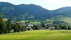 Unterammergau seen from the west | |
 Coat of arms | |
Location of Unterammergau within Garmisch-Partenkirchen district 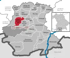 | |
 Unterammergau  Unterammergau | |
| Coordinates: 47°36.9′N 11°1.7′E / 47.6150°N 11.0283°E | |
| Country | Germany |
| State | Bavaria |
| Admin. region | Oberbayern |
| District | Garmisch-Partenkirchen |
| Municipal assoc. | Unterammergau |
| Government | |
| • Mayor (2020–26) | Robert Stumpfecker[1] |
| Area | |
| • Total | 29.90 km2 (11.54 sq mi) |
| Elevation | 836 m (2,743 ft) |
| Population (2022-12-31)[2] | |
| • Total | 1,589 |
| • Density | 53/km2 (140/sq mi) |
| Time zone | UTC+01:00 (CET) |
| • Summer (DST) | UTC+02:00 (CEST) |
| Postal codes | 82497 |
| Dialling codes | 08822 |
| Vehicle registration | GAP |
| Website | www.unterammergau.de |
Unterammergau is a municipality in the district of Garmisch-Partenkirchen, in Bavaria, Germany. It is the site of the 11th-century Chapel of St Leonhard, patron saint of horses, which is the terminus of the annual Leonhardritt and Blessing of the Animals.
Transport
The municipality has a railway station, Unterammergau, on the Ammergau Railway.
See also
References
- ↑ Liste der ersten Bürgermeister/Oberbürgermeister in kreisangehörigen Gemeinden, Bayerisches Landesamt für Statistik, 15 July 2021.
- ↑ Genesis Online-Datenbank des Bayerischen Landesamtes für Statistik Tabelle 12411-003r Fortschreibung des Bevölkerungsstandes: Gemeinden, Stichtag (Einwohnerzahlen auf Grundlage des Zensus 2011)
External links
Towns and municipalities in Garmisch-Partenkirchen (district) | ||
|---|---|---|
Coat of Arms of Garmisch-Partenkirchen district | ||
This article is issued from Wikipedia. The text is licensed under Creative Commons - Attribution - Sharealike. Additional terms may apply for the media files.