Upper Blue Licks | |
|---|---|
 Upper Blue Licks Location within the state of Kentucky  Upper Blue Licks Upper Blue Licks (the United States) | |
| Coordinates: 38°19′55″N 83°51′24″W / 38.33194°N 83.85667°W | |
| Country | United States |
| State | Kentucky |
| County | Nicholas |
| Elevation | 627 ft (191 m) |
| Time zone | UTC-5 (Eastern (EST)) |
| • Summer (DST) | UTC-4 (EDT) |
| GNIS feature ID | 509264[1] |
Upper Blue Licks is an unincorporated community located in Nicholas County, Kentucky, United States. Its post office closed in 1873.[2]
Area first discovered by Simon (Butler) Kenton and Thomas Williams. March, 1775
References
Municipalities and communities of Nicholas County, Kentucky, United States | ||
|---|---|---|
| City | 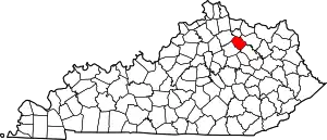 Location of Nicholas County, Kentucky | |
| Unincorporated communities | ||
This article is issued from Wikipedia. The text is licensed under Creative Commons - Attribution - Sharealike. Additional terms may apply for the media files.