Váralja | |
|---|---|
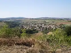 Váralja from Várfő-mount | |
 Flag  Coat of arms | |
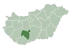
 Váralja Location of Váralja in Hungary | |
| Coordinates: 46°16′07″N 18°25′50″E / 46.26861°N 18.43056°E | |
| Country | Hungary |
| Region | Southern Transdanubia |
| County | Tolna |
| Area | |
| • Total | 21.1 km2 (8.1 sq mi) |
| Population (2011)[2] | |
| • Total | 876 |
| • Density | 42/km2 (110/sq mi) |
| Time zone | UTC+1 (CET) |
| • Summer (DST) | UTC+2 (CEST) |
| Postal code | 7354 |
| Area code | +36 74 |
| Website | www.varalja.hu |
Váralja is a village in Bonyhárd district, in Tolna county, Hungary.
References
- ↑ Váralja at the Hungarian Central Statistical Office (Hungarian).
- ↑ Váralja at the Hungarian Central Statistical Office (Hungarian). 2011
| City with county rights |
|   |
|---|---|---|
| Towns | ||
| Large villages | ||
| Villages |
| |
| Other topics |
| |
This article is issued from Wikipedia. The text is licensed under Creative Commons - Attribution - Sharealike. Additional terms may apply for the media files.