Vaľkovňa | |
|---|---|
Village | |
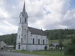 Lutheran church | |
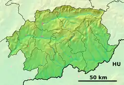 Vaľkovňa Location of Vaľkovňa in the Banská Bystrica Region  Vaľkovňa Vaľkovňa (Slovakia) | |
| Coordinates: 48°50′00″N 20°04′00″E / 48.83333°N 20.06667°E | |
| Country | Slovakia |
| Region | Banská Bystrica |
| District | Brezno |
| First mentioned | 1612 |
| Area | |
| • Total | 14.85[1] km2 (5.73[1] sq mi) |
| Elevation | 721[2] m (2,365[2] ft) |
| Population (2021) | |
| • Total | 421[3] |
| Postal code | 976 69[2] |
| Area code | +421 48[2] |
| Car plate | BR |
| Website | www.obecvalkovna.szm.sk |
Vaľkovňa (Hungarian: Nándorvölgy) is a village and municipality in Brezno District, in the Banská Bystrica Region of central Slovakia.
References
- 1 2 "Hustota obyvateľstva - obce [om7014rr_ukaz: Rozloha (Štvorcový meter)]". www.statistics.sk (in Slovak). Statistical Office of the Slovak Republic. 2022-03-31. Retrieved 2022-03-31.
- 1 2 3 4 "Základná charakteristika". www.statistics.sk (in Slovak). Statistical Office of the Slovak Republic. 2015-04-17. Retrieved 2022-03-31.
- ↑ "Počet obyvateľov podľa pohlavia - obce (ročne)". www.statistics.sk (in Slovak). Statistical Office of the Slovak Republic. 2022-03-31. Retrieved 2022-03-31.
External links
Municipalities of Brezno District | ||
|---|---|---|
This article is issued from Wikipedia. The text is licensed under Creative Commons - Attribution - Sharealike. Additional terms may apply for the media files.