Vierville | |
|---|---|
Part of Carentan-les-Marais | |
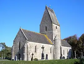 The church of Saint-Éloi | |
Location of Vierville | |
 Vierville  Vierville | |
| Coordinates: 49°21′40″N 1°14′43″W / 49.3611°N 1.2453°W | |
| Country | France |
| Region | Normandy |
| Department | Manche |
| Arrondissement | Saint-Lô |
| Canton | Carentan |
| Commune | Carentan-les-Marais |
| Area 1 | 4.10 km2 (1.58 sq mi) |
| Population (2019)[1] | 30 |
| • Density | 7.3/km2 (19/sq mi) |
| Time zone | UTC+01:00 (CET) |
| • Summer (DST) | UTC+02:00 (CEST) |
| Postal code | 50480 |
| Elevation | 2–23 m (6.6–75.5 ft) (avg. 36 m or 118 ft) |
| 1 French Land Register data, which excludes lakes, ponds, glaciers > 1 km2 (0.386 sq mi or 247 acres) and river estuaries. | |
Vierville (French pronunciation: [vjɛʁvil]) is a former commune in the Manche department in Normandy in north-western France. On 1 January 2019, it was merged into the commune Carentan-les-Marais.[2]
Places and monuments
- Mounds Neolithic of Butte (historical monument). Cemetery dating to the Merovingian.
- Church Saint-Eloi (XV), with font emblazoned (XVI).
- Castle (XVIII), listed in the inventory of historical monuments (IMH).
- Fontaine Saint-Eloi and laundry.
- Manoir de Tourville (XVII).
See also
References
- ↑ Téléchargement du fichier d'ensemble des populations légales en 2019, INSEE
- ↑ Arrêté préfectoral 6 December 2018 (in French)
Wikimedia Commons has media related to Vierville (Manche).
This article is issued from Wikipedia. The text is licensed under Creative Commons - Attribution - Sharealike. Additional terms may apply for the media files.