Werra-Suhl-Tal | |
|---|---|
Location of Werra-Suhl-Tal within Wartburgkreis district 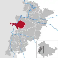 | |
 Werra-Suhl-Tal 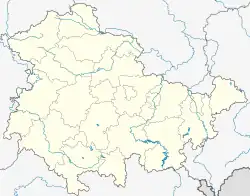 Werra-Suhl-Tal | |
| Coordinates: 50°56′N 10°04′E / 50.933°N 10.067°E | |
| Country | Germany |
| State | Thuringia |
| District | Wartburgkreis |
| Subdivisions | 10 |
| Government | |
| • Mayor (2022–28) | Maik Klotzbach[1] |
| Area | |
| • Total | 77.67 km2 (29.99 sq mi) |
| Elevation | 236 m (774 ft) |
| Population (2022-12-31)[2] | |
| • Total | 6,288 |
| • Density | 81/km2 (210/sq mi) |
| Time zone | UTC+01:00 (CET) |
| • Summer (DST) | UTC+02:00 (CEST) |
| Postal codes | 99837 |
| Dialling codes | 036922, 036925 |
| Vehicle registration | WAK |
Werra-Suhl-Tal is a town and a municipality in the Wartburgkreis district of Thuringia, Germany. It was created on 1 January 2019 by the merger of the municipalities of Berka/Werra, Dankmarshausen, Dippach and Großensee. Its name refers to the rivers Werra, Suhl (Weihe) and Suhl (Werra).
References
- ↑ Gewählte Bürgermeister - aktuelle Landesübersicht, Freistaat Thüringen, accessed 10 November 2022.
- ↑ "Bevölkerung der Gemeinden, erfüllenden Gemeinden und Verwaltungsgemeinschaften in Thüringen Gebietsstand: 31.12.2022" (in German). Thüringer Landesamt für Statistik. June 2023.
This article is issued from Wikipedia. The text is licensed under Creative Commons - Attribution - Sharealike. Additional terms may apply for the media files.