White Cliffs, New Mexico | |
|---|---|
 White Cliffs  White Cliffs | |
| Coordinates: 35°32′51″N 108°39′53″W / 35.54750°N 108.66472°W | |
| Country | United States |
| State | New Mexico |
| County | McKinley |
| Area | |
| • Total | 0.43 sq mi (1.11 km2) |
| • Land | 0.43 sq mi (1.11 km2) |
| • Water | 0.00 sq mi (0.00 km2) |
| Elevation | 6,590 ft (2,010 m) |
| Population | |
| • Total | 371 |
| • Density | 864.80/sq mi (334.13/km2) |
| Time zone | UTC-7 (Mountain (MST)) |
| • Summer (DST) | UTC-6 (MDT) |
| ZIP Codes | |
| Area code | 505 |
| FIPS code | 35-84505 |
| GNIS feature ID | 2806738[3] |
White Cliffs is an unincorporated community and census-designated place (CDP) in McKinley County, New Mexico, United States. It was first listed as a CDP prior to the 2020 census.[3]
The community is in the western part of the county, 5 miles (8 km) northeast of Gallup, the county seat. The CDP takes its name from a set of 600-foot-high (180 m) cliffs that rise 2 miles (3 km) to the north.
Demographics
| Census | Pop. | Note | %± |
|---|---|---|---|
| 2020 | 371 | — | |
| U.S. Decennial Census[4][2] | |||
Education
It is in Gallup-McKinley County Public Schools.[5]
References
- ↑ "ArcGIS REST Services Directory". United States Census Bureau. Retrieved October 12, 2022.
- 1 2 "Census Population API". United States Census Bureau. Retrieved October 12, 2022.
- 1 2 "White Cliffs Census Designated Place". Geographic Names Information System. United States Geological Survey, United States Department of the Interior.
- ↑ "Census of Population and Housing". Census.gov. Retrieved June 4, 2016.
- ↑ "2020 CENSUS - SCHOOL DISTRICT REFERENCE MAP: McKinley County, NM" (PDF). U.S. Census Bureau. Retrieved July 20, 2021.
Municipalities and communities of McKinley County, New Mexico, United States | ||
|---|---|---|
| City | 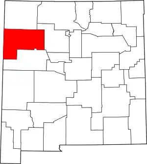 Map of New Mexico highlighting McKinley County | |
| CDPs |
| |
| Other communities | ||
| Indian reservation | ||
| Footnotes | ‡This populated place also has portions in an adjacent county or counties | |
This article is issued from Wikipedia. The text is licensed under Creative Commons - Attribution - Sharealike. Additional terms may apply for the media files.