| Wietze | |
|---|---|
 | |
| Location | |
| Country | Germany |
| State | Lower Saxony |
| Reference no. | 4872 |
| Physical characteristics | |
| Source | |
| • location | Source: north east of Altwarmbüchen (a district of Isernhagen), at confluence of Flöth and Edder |
| • coordinates | 52°26′47″N 9°51′59″E / 52.4465194°N 09.8662806°E |
| • elevation | 56 m (Flöth 60 m above NN, Eder 59 m above NN) |
| Mouth | |
• location | north west of Wietze into the Aller |
• coordinates | 52°39′54″N 9°48′22″E / 52.6649083°N 09.8059917°E |
• elevation | 28 m |
| Length | 41.0 km (25.5 mi)[1] |
| Basin size | 514 km2 (198 sq mi) [1] |
| Basin features | |
| Progression | Aller→ Weser→ North Sea |
| Landmarks |
|
| Tributaries | |
| • left | Laher Graben, Johannisgraben (Mühlengraben), |
| • right | Wiesenbach, Hengstbeeke, Wulbeck, Rixförder Graben, Fuhrengraben |
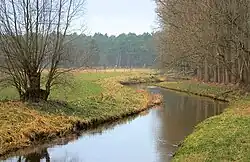
Wietze is a river of Lower Saxony, Germany, a tributary of the Aller. Its total length including its source river Edder (length 3.4 km (2.1 mi)) is 41.0 km (25.5 mi).[1]
Geography
The river begins at the confluence of the Edder and Flöth northeast of Hanover near Altwarmbüchen, a district of Isernhagen. From there it flows several kilometres to the west through the southern part of Isernhagen to Langenhagen and from there on only in a northern direction to just beyond the village of Wietze, where it merges with the River Aller flowing from the south.
In the second half of its course the Wietze forms a pronounced depression with a bog-like region known as the Wietzenbruch. This is a region of extensive forest and fen woodland (Bruchwald) about 400 square kilometres (150 sq mi) in area. Wietzenbruch, a suburb of the town of Celle lies next to it.
The name of the river is derived from wizene ("wych elm river").
See also
References
External links
- Landscape fact file of Wietzenbruch with map from the Bundesamt für Naturschutz
- NLWK water quality report Fuhse/Wietze 2003 (pdf file; 6,30 MB)