Wildsteig | |
|---|---|
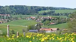 Wildsteig seen from the south | |
 Coat of arms | |
Location of Wildsteig within Weilheim-Schongau district 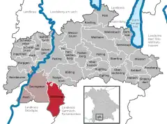 | |
 Wildsteig  Wildsteig | |
| Coordinates: 47°42′N 10°57′E / 47.700°N 10.950°E | |
| Country | Germany |
| State | Bavaria |
| Admin. region | Oberbayern |
| District | Weilheim-Schongau |
| Municipal assoc. | Steingaden |
| Government | |
| • Mayor (2020–26) | Josef Taffertshofer[1] |
| Area | |
| • Total | 47.73 km2 (18.43 sq mi) |
| Elevation | 875 m (2,871 ft) |
| Population (2022-12-31)[2] | |
| • Total | 1,359 |
| • Density | 28/km2 (74/sq mi) |
| Time zone | UTC+01:00 (CET) |
| • Summer (DST) | UTC+02:00 (CEST) |
| Postal codes | 82409 |
| Dialling codes | 08867 |
| Vehicle registration | WM |
| Website | www.wildsteig.de |
Wildsteig is a municipality in the Weilheim-Schongau district, in Bavaria, Germany.
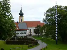
St Jakob church, Maypole, War monument seen from the Kirchbergstrasse
References
- ↑ Liste der ersten Bürgermeister/Oberbürgermeister in kreisangehörigen Gemeinden, Bayerisches Landesamt für Statistik, 15 July 2021.
- ↑ Genesis Online-Datenbank des Bayerischen Landesamtes für Statistik Tabelle 12411-003r Fortschreibung des Bevölkerungsstandes: Gemeinden, Stichtag (Einwohnerzahlen auf Grundlage des Zensus 2011)
Wikimedia Commons has media related to Wildsteig.
This article is issued from Wikipedia. The text is licensed under Creative Commons - Attribution - Sharealike. Additional terms may apply for the media files.