Wilhermsdorf | |
|---|---|
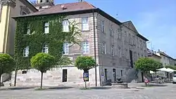 Ritterhaus | |
 Coat of arms | |
Location of Wilhermsdorf within Fürth district 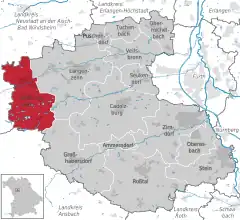 | |
 Wilhermsdorf  Wilhermsdorf | |
| Coordinates: 49°29′11″N 10°43′05″E / 49.48639°N 10.71806°E | |
| Country | Germany |
| State | Bavaria |
| Admin. region | Mittelfranken |
| District | Fürth |
| Subdivisions | 10 Ortsteile |
| Government | |
| • Mayor (2020–26) | Uwe Emmert[1] (CSU) |
| Area | |
| • Total | 26.64 km2 (10.29 sq mi) |
| Elevation | 322 m (1,056 ft) |
| Population (2022-12-31)[2] | |
| • Total | 5,538 |
| • Density | 210/km2 (540/sq mi) |
| Time zone | UTC+01:00 (CET) |
| • Summer (DST) | UTC+02:00 (CEST) |
| Postal codes | 91452 |
| Dialling codes | 09102 |
| Vehicle registration | FÜ |
| Website | www.markt-wilhermsdorf.de |
Wilhermsdorf is a municipality in the district of Fürth in Bavaria in Germany. As of 2020 it has a population of 5,479. It is twinned with Feld am See in Austria and Jahnsdorf, also in Germany.
Neighboring municipalities
Wilhermsdorf borders
References
- ↑ Liste der ersten Bürgermeister/Oberbürgermeister in kreisangehörigen Gemeinden, Bayerisches Landesamt für Statistik, 15 July 2021.
- ↑ Genesis Online-Datenbank des Bayerischen Landesamtes für Statistik Tabelle 12411-003r Fortschreibung des Bevölkerungsstandes: Gemeinden, Stichtag (Einwohnerzahlen auf Grundlage des Zensus 2011)
Towns and municipalities in Fürth (district) | ||
|---|---|---|
This article is issued from Wikipedia. The text is licensed under Creative Commons - Attribution - Sharealike. Additional terms may apply for the media files.