Wurno | |
|---|---|
LGA and town | |
 Wurno | |
| Coordinates: 13°17′3″N 5°25′39″E / 13.28417°N 5.42750°E | |
| Country | |
| State | Sokoto State |
| Area | |
| • Total | 685 km2 (264 sq mi) |
| Population (2006) | |
| • Total | 162,307 |
| Time zone | UTC+1 (WAT) |
| 3-digit postal code prefix | 842 |
| ISO 3166 code | NG.SO.WU |
Wurno is a Local Government Area in Sokoto State, Nigeria. Its headquarters is in the town of Wurno, near the Gagere River.
It has an area of 685 km2 and a population of 162,307 at the 2006 census.[1]
The postal code of the area is 842.[2]
Climate
A hot, oppressive rainy season with predominantly cloudy skies and a scorching, partly cloudy dry season with temperatures between 62°F and 105°F are both characteristics of the climate.[3][4][5]
References
- ↑ HASC, population, area and Headquarters Statoids
- ↑ "Post Offices- with map of LGA". NIPOST. Retrieved 2009-10-20.
- ↑ "Wurno Climate, Weather By Month, Average Temperature (Nigeria) - Weather Spark". weatherspark.com. Retrieved 2023-09-01.
- ↑ "Wurno, Sokoto, NG Climate Zone, Monthly Averages, Historical Weather Data". tcktcktck.org. Retrieved 2023-09-01.
- ↑ "Wurno, Sokoto, Nigeria - City, Town and Village of the world". en.db-city.com. Retrieved 2023-09-01.
State capital: Sokoto | ||
| Local Government Areas | 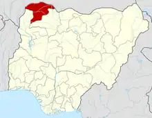 | |
This article is issued from Wikipedia. The text is licensed under Creative Commons - Attribution - Sharealike. Additional terms may apply for the media files.