47 92 23 | |
|---|---|
| 양재대로 | |
| Route information | |
| Length | 19.36 km (12.03 mi) |
| Existed | 12 July 1988–present |
| Major junctions | |
| From | Seocho District, Seoul |
| To | Guri, Gyeonggi Province |
| Location | |
| Country | South Korea |
| Highway system | |
| National Route 47 Seoul City Route 31 Local Route 23 | |
Yangjae-daero (Korean: 양재대로) is a road located in Gyeonggi Province and Seoul, South Korea. With a total length of 19.36 km (12.03 mi), this road starts from the Seonam Interchange in Seocho District, Seoul to Acheon Interchange in Guri, Gyeonggi.
Stopovers
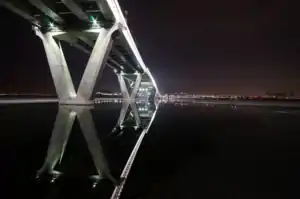
Below Guri-Amsa Bridge at night.
_1.jpg.webp)
Yangjae-daero near Yeomgok Intersection.
List of Facilities
- (■): Motorway section
IS: Intersection, IC: Interchange
47
92
23
| Name [1] | Hangul name | Connection | Location | Note | |
|---|---|---|---|---|---|
| Connected with Seoul City Route 94 Gangnam Beltway, Jungang-ro | |||||
| Seonam IC | 선암 나들목 | Seoul City Route 31 (Umyeonsan-ro) Seoul City Route 94 (Gangnam Beltway) Taebong-ro |
Seoul | Seocho District | Seonam Underpass(One-way) |
| Juam Bridge | 주암교 | Gwacheon | Juam-dong | National Route 47 overlap | |
| Truck Terminal | 트럭터미널앞 | Maeheon-ro Yangjae-daero 11-gil Yangjae-daero 12-gil |
Seoul | Seocho District | |
| Yangjae IC | 양재 나들목 | Gyeongbu Expressway | |||
| Yeomgok IS | 염곡사거리 | Seoul City Route 41 (Gangnam-daero) (Heolleung-ro) | |||
| Guryongsa IS | 구룡사앞 교차로 | Nonhyeon-ro | Gangnam District | Guryong Underpass section National Route 47 overlap | |
| Guryong Tunnel IS | 구룡터널 교차로 | Seoul City Route 51 (Eonju-ro) (Bundang-Naegok Urban Expressway) |
National Route 47 overlap | ||
| Guryongma-eul Entrance IS | 구룡마을입구 교차로 | Seolleung-ro Yangjae-daero 16-gil | |||
| Gaepo 3, 4 Complex IS | 개포3,4단지 교차로 | Samseong-ro | |||
| Irwon Tunnel IS | 일원터널 교차로 | National Route 47 Local Route 23 (Yeongdong-daero) Gwangpyeong-ro |
Irwon Underpass section National Route 47 overlap Local Route 23 overlap | ||
| Samsung Seoul Hospital IS | 삼성서울병원사거리 | Irwon-ro | Local Route 23 overlap | ||
| Irwon 1-dong Community Center IS | 일원1동주민센터앞 교차로 | Yangjae-daero 55-gil | |||
| Suseo IC | 수서 나들목 | Local Route 23 (Bamgogae-ro) Seoul City Route 61 (Dongbu Expressway) Seoul City Route 92 (Nambu Beltway) |
Local Route 23 overlap Seoul City Route 92 overlap | ||
| Tancheon Bridge | 탄천교 | Seoul City Route 92 overlap | |||
| Songpa District | |||||
| Tancheon Bridge IS | 탄천교 교차로 | Tancheondong-ro | |||
| Garak Market Entrance IS | 가락시장입구 교차로 | Garak Market | Garak Underpass section Seoul City Route 92 overlap | ||
| Garak Market IS | 가락시장 교차로 | National Route 3 Seoul City Route 71 (Songpa-daero) |
Seoul City Route 92 overlap | ||
| Singa Elementary School IS | 신가초교앞 교차로 | Sungi-ro | |||
| Ogeum IS | 오금사거리 | Ogeum-ro | |||
| Bangi station IS | 방이역사거리 | Macheon-ro | |||
| Olympic Park IS | 올림픽공원사거리 | Wiryeseong-daero | |||
| Olympic Park East Gate IS (Olympic Park station) |
올림픽공원동문 교차로 (올림픽공원역) |
||||
| Dunchondari | 둔촌다리 | ||||
| Korea National Sport University Seoul Seryun Elementary School Boseong High School Boseong Middle School |
한국체육대학교 서울세륜초등학교 보성고등학교 보성중학교 | ||||
| Dunchon IS | 둔촌사거리 | Seoul City Route 60 (Gangdong-daero) | |||
| Gangdong District | |||||
| Dunchon-dong station IS | 둔촌동역 교차로 | Pungseong-ro | |||
| Gildong IS | 길동사거리 | National Route 43 Seoul City Route 50 (Cheonho-daero) | |||
| Gildong station | 길동역 | ||||
| Cheondong Elementary School Entrance IS | 천동초교입구 교차로 | Cheonjung-ro | |||
| Gubeundari station IS | 굽은다리역 교차로 | Sangam-ro | |||
| Myeongil station IS | 명일역 교차로 | Gucheonmyeon-ro | |||
| Dongbu Technical Education Center IS | 동부기술교육원 교차로 | Godeok-ro | |||
| Amsa Water Purification Facilities IS | 암사정수센터 교차로 | Arisu-ro | |||
| Amsa IC | 암사 나들목 | Seoul City Route 88 (Olympic-daero) | |||
| Guri-Amsa Bridge | 구리암사대교 | ||||
| Guri | Gyomun-dong | ||||
| Acheon IC | 아천 나들목 | Gangbyeonbuk-ro | |||
| Connected with Sagajeong-ro | |||||
References
- ↑ Intersection and interchange are also included , as well as buildings and facilities in the surrounding area
| Railways |
| ||||||||||||||||
|---|---|---|---|---|---|---|---|---|---|---|---|---|---|---|---|---|---|
| Roads |
| ||||||||||||||||
| Buses |
| ||||||||||||||||
| Airports | |||||||||||||||||
| Related topics |
| ||||||||||||||||
This article is issued from Wikipedia. The text is licensed under Creative Commons - Attribution - Sharealike. Additional terms may apply for the media files.