Ymittos
Υμηττός | |
|---|---|
 Ymittos Location within Athens 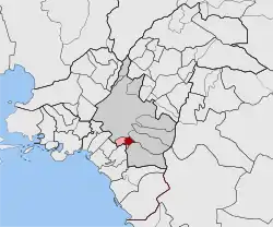 | |
| Coordinates: 37°57′N 23°44′E / 37.950°N 23.733°E | |
| Country | Greece |
| Administrative region | Attica |
| Regional unit | Central Athens |
| Municipality | Dafni-Ymittos |
| • Municipal unit | 0.975 km2 (0.376 sq mi) |
| Elevation | 130 m (430 ft) |
| Population (2011)[1] | |
| • Municipal unit | 10,715 |
| • Municipal unit density | 11,000/km2 (28,000/sq mi) |
| Time zone | UTC+2 (EET) |
| • Summer (DST) | UTC+3 (EEST) |
| Postal code | 172 36&37 |
| Area code(s) | 210 |
| Vehicle registration | Z |
| Website | dafni-ymittos.gov.gr |
Ymittos (Greek: Υμηττός), is a town and a suburb in the Athens urban area, Greece. Since the 2011 local government reform it is part of the municipality Dafni-Ymittos, of which it is a municipal unit.[2] With a land area of 0.975 km², it was the second-smallest municipality in Greece (after Nea Chalkidona) before 2011. It is situated 2.5 km southeast of the Acropolis of Athens. Ymittos has two lyceums.
Historical population
| Year | Population |
|---|---|
| 1981 | 12,491 |
| 1991 | 11,671 |
| 2001 | 11,139 |
| 2011 | 10,715 |
| 2021 | 10,455[3] |
References
- ↑ "Απογραφή Πληθυσμού - Κατοικιών 2011. ΜΟΝΙΜΟΣ Πληθυσμός" (in Greek). Hellenic Statistical Authority.
- ↑ "ΦΕΚ B 1292/2010, Kallikratis reform municipalities" (in Greek). Government Gazette.
- ↑ "Resident population results by municipality, 04/21/2023". statistics.gr. Retrieved 2023-10-13.
External links
- Ymittos weather station (in Greek)
Places adjacent to Ymittos | ||||||||||||||||
|---|---|---|---|---|---|---|---|---|---|---|---|---|---|---|---|---|
| ||||||||||||||||
This article is issued from Wikipedia. The text is licensed under Creative Commons - Attribution - Sharealike. Additional terms may apply for the media files.