Zajasovnik | |
|---|---|
 | |
 Zajasovnik Location in Slovenia | |
| Coordinates: 46°12′31″N 14°54′8.23″E / 46.20861°N 14.9022861°E | |
| Country | |
| Traditional region | Upper Carniola, Styria |
| Statistical region | Central Slovenia |
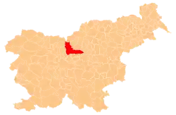
| Municipality | Kamnik, Vransko |
| Area | |
| • Total | 3.08 km2 (1.19 sq mi) |
| Elevation | 541.4 m (1,776.2 ft) |
| Population (2002) | |
| • Total | 77 |
| [1] | |
Zajasovnik (pronounced [zaˈjaːsɔu̯nik]) is a dispersed settlement that is divided between the municipalities of Kamnik and Vransko in Slovenia.
Cultural heritage
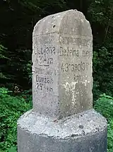
Austro-Hungarian boundary stone
An Austro-Hungarian boundary stone marking the border between Carniola and Styria stands at the border between the two parts of Zajasovnik.[2]
References
- ↑ Statistical Office of the Republic of Slovenia Archived November 18, 2008, at the Wayback Machine
- ↑ "Zajasovnik - Mejni deželni kamen". Register kulturne dediščine. Ministrstvo za kulturo. Retrieved June 29, 2021.
External links
 Media related to Zajasovnik at Wikimedia Commons
- Zajasovnik (Kamnik) on Geopedia
- Zajasovnik (Vransko) on Geopedia
| Settlements | 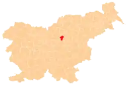 | |
|---|---|---|
| Landmarks |
| |
This article is issued from Wikipedia. The text is licensed under Creative Commons - Attribution - Sharealike. Additional terms may apply for the media files.