Černýšovice | |
|---|---|
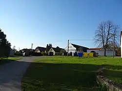 Centre of Černýšovice | |
 Černýšovice Location in the Czech Republic | |
| Coordinates: 49°19′31″N 14°31′14″E / 49.32528°N 14.52056°E | |
| Country | |
| Region | South Bohemian |
| District | Tábor |
| First mentioned | 1390 |
| Area | |
| • Total | 10.14 km2 (3.92 sq mi) |
| Elevation | 431 m (1,414 ft) |
| Population (2023-01-01)[1] | |
| • Total | 84 |
| • Density | 8.3/km2 (21/sq mi) |
| Time zone | UTC+1 (CET) |
| • Summer (DST) | UTC+2 (CEST) |
| Postal code | 391 65 |
| Website | www |
Černýšovice is a municipality and village in Tábor District in the South Bohemian Region of the Czech Republic. It has about 80 inhabitants.
Černýšovice lies approximately 15 kilometres (9 mi) south-west of Tábor, 39 km (24 mi) north of České Budějovice, and 85 km (53 mi) south of Prague.
Administrative parts
The village of Hutě is an administrative part of Černýšovice.
Gallery
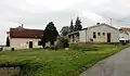 Municipal office and a shop
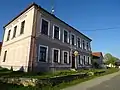 Former school
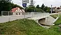 Entrance to Černýšovice
References
Wikimedia Commons has media related to Černýšovice.
This article is issued from Wikipedia. The text is licensed under Creative Commons - Attribution - Sharealike. Additional terms may apply for the media files.