Radimovice u Želče | |
|---|---|
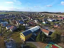 View from the southeast | |
 Flag  Coat of arms | |
 Radimovice u Želče Location in the Czech Republic | |
| Coordinates: 49°22′38″N 14°38′51″E / 49.37722°N 14.64750°E | |
| Country | |
| Region | South Bohemian |
| District | Tábor |
| First mentioned | 1307 |
| Area | |
| • Total | 4.49 km2 (1.73 sq mi) |
| Elevation | 482 m (1,581 ft) |
| Population (2023-01-01)[1] | |
| • Total | 426 |
| • Density | 95/km2 (250/sq mi) |
| Time zone | UTC+1 (CET) |
| • Summer (DST) | UTC+2 (CEST) |
| Postal code | 390 02 |
| Website | www |
Radimovice u Želče is a municipality and village in Tábor District in the South Bohemian Region of the Czech Republic. It has about 400 inhabitants.
Radimovice u Želče lies approximately 5 kilometres (3 mi) south of Tábor, 47 km (29 mi) north of České Budějovice, and 81 km (50 mi) south of Prague.
References
Wikimedia Commons has media related to Radimovice u Želče.
This article is issued from Wikipedia. The text is licensed under Creative Commons - Attribution - Sharealike. Additional terms may apply for the media files.