| Acre Subdistrict قضاء عكا נפת עכו | |||||||||
|---|---|---|---|---|---|---|---|---|---|
| Subdistrict of Mandatory Palestine | |||||||||
| 1920–1948 | |||||||||
| Capital | Acre | ||||||||
| Area | |||||||||
• 1945 | 799 km2 (308 sq mi) | ||||||||
| Population | |||||||||
• 1904 | 31593 | ||||||||
• 1945 | 68330 | ||||||||
| History | |||||||||
• Established | 1920 | ||||||||
• Disestablished | 1948 | ||||||||
| |||||||||
| Today part of | Israel | ||||||||
The Acre Subdistrict (Arabic: قضاء عكا, Qadaa Akka; Hebrew: נפת עכו, Nefat Akko) was one of the subdistricts of Mandatory Palestine. It was located in modern-day northern Israel, having nearly the same territory, as the modern-day Acre County. The city of Acre was the district's capital.
The subdistrict was transformed into Northern District's Acre Subdistrict.
Borders
- Safad Subdistrict (East)
- Tiberias Subdistrict (East)
- Nazareth Subdistrict (South)
- Haifa Subdistrict (South West)
- Lebanon (North)
History of attachment to a district
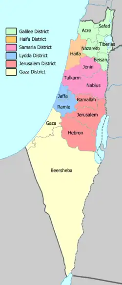
Districts and Sub-Districts of Palestine in 1945.
The layout of the districts of Mandatory Palestine changed several times:
- 1922 Northern District
- 1937 Galilee District
- 1939 Galilee and Acre District
- 1940 Galilee District
- 1948 dissolution
The territory is now covered by the Northern District of Israel.
Depopulated towns and villages
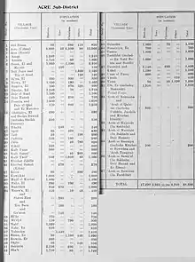
Official population statistics for the sub-district, from Village Statistics, 1945.
(current localities in parentheses)
32°35′00″N 35°00′00″E / 32.5833°N 35.0000°E
This article is issued from Wikipedia. The text is licensed under Creative Commons - Attribution - Sharealike. Additional terms may apply for the media files.