Alamo Lake, Arizona | |
|---|---|
 Location of Alamo Lake in La Paz County, Arizona | |
 Alamo Lake  Alamo Lake | |
| Coordinates: 34°15′32″N 113°30′28″W / 34.25889°N 113.50778°W | |
| Country | United States |
| State | Arizona |
| County | La Paz |
| Area | |
| • Total | 46.56 sq mi (120.59 km2) |
| • Land | 43.95 sq mi (113.82 km2) |
| • Water | 2.62 sq mi (6.78 km2) |
| Elevation | 1,316 ft (401 m) |
| Population (2020) | |
| • Total | 4 |
| • Density | 0.09/sq mi (0.04/km2) |
| Time zone | UTC-7 (Mountain (MST)) |
| Area code | 928 |
| GNIS feature ID | 2582722 |
| FIPS code | 04-01170 |
Alamo Lake is a census-designated place in La Paz County, Arizona, United States. Its population was 4 as of the 2020 census. The community includes Alamo Lake State Park.
Demographics
| Census | Pop. | Note | %± |
|---|---|---|---|
| 2010 | 25 | — | |
| 2020 | 4 | −84.0% | |
| U.S. Decennial Census[2] | |||
Alamo Lake first appeared on the 2010 U.S. Census as a census-designated place (CDP). With 25 residents, it is the second-smallest community in La Paz County after Sunwest.
References
- ↑ "2020 U.S. Gazetteer Files". United States Census Bureau. Retrieved October 29, 2021.
- ↑ "Census of Population and Housing". Census.gov. Retrieved June 4, 2016.
Municipalities and communities of La Paz County, Arizona, United States | ||
|---|---|---|
| Towns | 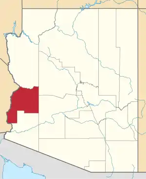 | |
| CDPs | ||
| Populated places | ||
| Indian reservations | ||
| Ghost towns | ||
This article is issued from Wikipedia. The text is licensed under Creative Commons - Attribution - Sharealike. Additional terms may apply for the media files.