Amboasary Sud
Amboasary Atsimo | |
|---|---|
 Near Amboasary Sud | |
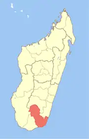
 Amboasary Sud Location in Madagascar | |
| Coordinates: 25°3′S 46°23′E / 25.050°S 46.383°E | |
| Country | |
| Region | Anosy |
| District | Amboasary Sud |
| Government | |
| • Mayor | Richard Joseph Rakotonirina |
| Area | |
| • Total | 248 km2 (96 sq mi) |
| Elevation | 26 m (85 ft) |
| Population (2018) | |
| • Total | 45,989 |
| Time zone | UTC3 (EAT) |
| postal code | 603 |
Amboasary Sud (Amboasary Atsimo) is a town in Anosy, Madagascar. It is the main town of Amboasary Sud District. It has a population of 45,989 in 2018.
Geography
It is located at the Mandrare River which since 1957 is crossed by a steel bridge of 414m was built, that was designed by Anciens Ets Eiffel.[2] It is situated approximately 75 km from Fort-Dauphin and 35 km from Ambovombe.
Economy
The economy of the town is dominated by sisal plantations and 3 transforming companies.[3]
Lakes
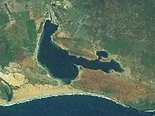
the Anony Lake
The Anony Lake (2 300 ha) at 17 km south from Amboasary Sud and the Ranofotsy Lake (500ha).[4]
Sports
- FC Amboasary Atsimo (regional soccer champion 2011 & 2012)
- ASMO Amboasary (regional soccer champion 2020)
Points of interest
- The privately owned Berenty Reserve is close to Amboasary.
- Bay of Italy (Italy significates Where there is the wind in Malgache language)
- Anony Lake with its flamingoes and the caves called Jurassique Cirque (Jurassic Circus).
Infrastructures
The town is linked to Fort-Dauphin by the National road 13 (73 km).
References
Capital: Fort Dauphin (Taolagnaro) | ||
| Amboasary Sud (18) - 603 |
|  |
| Betroka (20) - 613 | ||
| Taolagnaro (24) - 614 | ||
3 districts; 62 communes | ||
This article is issued from Wikipedia. The text is licensed under Creative Commons - Attribution - Sharealike. Additional terms may apply for the media files.