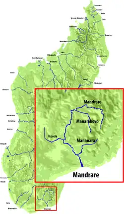
| Mandrare River | |
|---|---|
 | |
| Location | |
| Country | Madagascar |
| Region | Anosy |
| Cities | Mahaly, Amboasary Sud, Berenty, Mahaly |
| Physical characteristics | |
| Source | |
| • location | Beampingaratra massif near Trafonaomby peak |
| • elevation | 1,800 m (5,900 ft) |
| Mouth | Indian Ocean |
• location | Anosy |
• coordinates | 25°10′26″S 46°26′00″E / 25.17389°S 46.43333°E |
• elevation | 0 m (0 ft) |
| Length | 270 km (170 mi) |
| Basin size | 12,435[1] km2 (4,801 sq mi) |
| Basin features | |
| Progression | Amboasary Sud |
| Tributaries | |
| • left | Manambovo River (above Mahaly), Mananara River (Anosy) (above Amboasary Sud) |
| • right | Andratina River |
Mandrare is a river in the region of Anosy in southern Madagascar. It flows into the Indian Ocean near Amboasary Sud. It becomes dry in certain months of the year.[1]
In 1957, near Amboasary Sud a steel bridge of 414m was built, that was designed by Anciens Ets Eiffel.
See also
References
- 1 2 "Madagascar-GEOGRAPHY". countrystudies.us. U. S. Library of Congress. Retrieved 27 September 2017.
This article is issued from Wikipedia. The text is licensed under Creative Commons - Attribution - Sharealike. Additional terms may apply for the media files.