Anglards-de-Saint-Flour | |
|---|---|
Location of Anglards-de-Saint-Flour | |
 Anglards-de-Saint-Flour  Anglards-de-Saint-Flour | |
| Coordinates: 44°58′55″N 3°09′16″E / 44.9819°N 3.1544°E | |
| Country | France |
| Region | Auvergne-Rhône-Alpes |
| Department | Cantal |
| Arrondissement | Saint-Flour |
| Canton | Neuvéglise-sur-Truyère |
| Intercommunality | Saint-Flour Communauté |
| Government | |
| • Mayor (2020–2026) | Roland Brunel[1] |
| Area 1 | 12.28 km2 (4.74 sq mi) |
| Population | 386 |
| • Density | 31/km2 (81/sq mi) |
| Time zone | UTC+01:00 (CET) |
| • Summer (DST) | UTC+02:00 (CEST) |
| INSEE/Postal code | 15005 /15100 |
| Elevation | 732–884 m (2,402–2,900 ft) (avg. 840 m or 2,760 ft) |
| 1 French Land Register data, which excludes lakes, ponds, glaciers > 1 km2 (0.386 sq mi or 247 acres) and river estuaries. | |
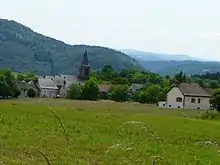
Anglards-de-Saint-Flour bourg
Anglards-de-Saint-Flour (French pronunciation: [ɑ̃ɡlaʁ də sɛ̃ fluʁ]; Auvergnat: Anglars de Sant Flor) is a commune in the Cantal department in the Auvergne region in south-central France.
Population
| Year | Pop. | ±% p.a. |
|---|---|---|
| 1968 | 227 | — |
| 1975 | 217 | −0.64% |
| 1982 | 225 | +0.52% |
| 1990 | 276 | +2.59% |
| 1999 | 283 | +0.28% |
| 2007 | 318 | +1.47% |
| 2012 | 347 | +1.76% |
| 2017 | 349 | +0.12% |
| Source: INSEE[3] | ||
See also
References
- ↑ "Répertoire national des élus: les maires". data.gouv.fr, Plateforme ouverte des données publiques françaises (in French). 2 December 2020.
- ↑ "Populations légales 2021". The National Institute of Statistics and Economic Studies. 28 December 2023.
- ↑ Population en historique depuis 1968, INSEE
Wikimedia Commons has media related to Anglards-de-Saint-Flour.
This article is issued from Wikipedia. The text is licensed under Creative Commons - Attribution - Sharealike. Additional terms may apply for the media files.