Arzfeld | |
|---|---|
 | |
 Coat of arms | |
Location of Arzfeld within Eifelkreis Bitburg-Prüm district 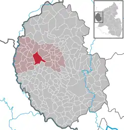 | |
 Arzfeld  Arzfeld | |
| Coordinates: 50°5′20″N 6°16′31″E / 50.08889°N 6.27528°E | |
| Country | Germany |
| State | Rhineland-Palatinate |
| District | Eifelkreis Bitburg-Prüm |
| Municipal assoc. | Arzfeld |
| Government | |
| • Mayor (2019–24) | Walter Heinisch[1] (CDU) |
| Area | |
| • Total | 19.38 km2 (7.48 sq mi) |
| Elevation | 490 m (1,610 ft) |
| Population (2021-12-31)[2] | |
| • Total | 1,420 |
| • Density | 73/km2 (190/sq mi) |
| Time zone | UTC+01:00 (CET) |
| • Summer (DST) | UTC+02:00 (CEST) |
| Postal codes | 54687 |
| Dialling codes | 06550 |
| Vehicle registration | BIT |
| Website | www.vg-arzfeld.de |
Arzfeld is a municipality in the district Bitburg-Prüm, in Rhineland-Palatinate, Germany. It is situated in the Eifel, near the border with Luxembourg, approximately 20 km north-west of Bitburg and 25 km south-east of Sankt-Vith.
Arzfeld is the seat of the Verbandsgemeinde ("collective municipality") Arzfeld.
References
- ↑ Direktwahlen 2019, Eifelkreis Bitburg-Prüm, Landeswahlleiter Rheinland-Pfalz, accessed 6 August 2021.
- ↑ "Bevölkerungsstand 2021, Kreise, Gemeinden, Verbandsgemeinden" (in German). Statistisches Landesamt Rheinland-Pfalz. 2022.
This article is issued from Wikipedia. The text is licensed under Creative Commons - Attribution - Sharealike. Additional terms may apply for the media files.